Atlas of Battles

battle, major, medieval

Battle of Taginae

Battle of Taginae was a battle fought in June AD 552 at Gualdo Tadino, in what is now Italy. It was part of the Gothic War of 535–554, which ran from AD 535 to AD 554. The recorded result: Byzantine victory.

See it on the globe Read the article

A history of the art of war, the middle ages from the fourth to the fourteenth century (1898) - Battle of Taginae - map
A history of the art of war, the middle ages from the fourth to the fourteenth century (1898) - Battle of Taginae - map. Charles Omanː A history of the art of war, the middle ages from the fourth to the fourteenth century (1898), Public domain, via Wikimedia Commons.
FoughtJune AD 552
WhereGualdo Tadino, Italy43.233N, 12.783E
OutcomeByzantine victory
BelligerentsByzantine EmpireagainstOstrogothic Kingdom
Part ofGothic War of 535–554AD 535 to AD 554

Where it sits in the Gothic War of 535–554

Battle of Scardon, AD 535Siege of Panormus, AD 535Siege of Naples, AD 536Siege of Rome, AD 537Siege of Urbinus, AD 538Battle of Pavia, AD 538Siege of Ariminum, AD 538Siege of Milan, AD 538Siege of Ravenna, AD 539Siege of Auximus, AD 539Siege of Verona, AD 541Battle of Treviso, AD 541Battle of Faventia, AD 542Battle of Mucellium, AD 542Siege of Naples, AD 542Sack of Rome, AD 546Siege of Rossano, AD 548Siege of Rome, AD 549Battle of Sena Gallica, AD 551Battle of Taginae, AD 552Siege of Cumae, AD 552Battle of Mons Lactarius, AD 552Siege of Urviventus, AD 553Battle of the Volturnus, AD 554AD 535AD 554Battle of Taginae, AD 552
25 placed engagements of the Gothic War of 535–554 in time order; taller ticks are more widely documented. Each tick is a link.

Record

DateJune AD 552 (month precision)
PlaceGualdo Tadino, Italy
43.233N, 12.783E
KindBattle, medieval
StrengthLarger force
Commanders
Battle of TaginaeBattle of TaginaeBattle of SentinumBattle of CamerinumBattle of CanturinoBattle of PerugiaBattle of CingoliBattle of SentinumBattle of CamerinumBattle of CanturinoBattle of PerugiaFlorencePescaraRavennaL'AquilaCivitavecchiaSienaSan Marino100 km43.233N, 12.783E
The recorded site, with the nearest other engagements in the atlas. Present-day coastlines, rivers and borders; towns from Natural Earth.

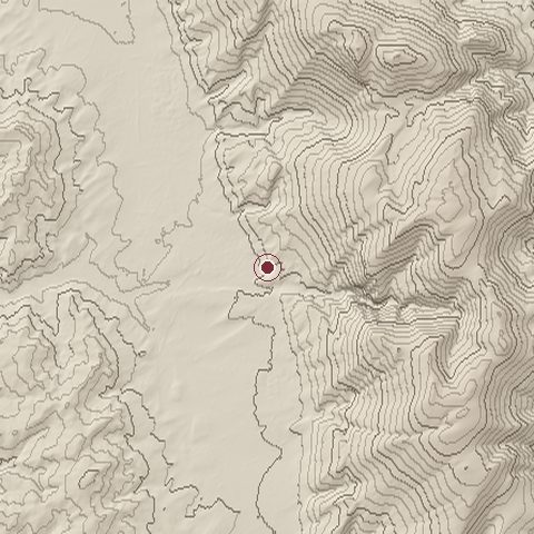
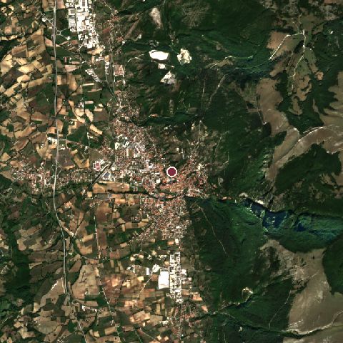
The ground today

Relief of the ground around the site of Battle of Taginae
Relief within about 10.0 km of the site, contours every 50 m. Copernicus DEM GLO-30, ESA.
Satellite view of the site of Battle of Taginae today
The same ground from Sentinel-2 on 2023-10-02. Contains modified Copernicus Sentinel data 2023.

The recorded site stands at about 521 m; within 10.0 km the ground runs from 391 to 1,429 m, 1,038 m of relief, mountainous country and today it is 47% tree cover, 20% grassland, 18% cropland.

tree cover: 47%grassland: 20%cropland: 18%built-up: 11%shrubland: 4%tree cover 47%grassland 20%cropland 18%built-up 11%shrubland 4%
west to east, 10.0 km440 to 1,300 mnorth to south, 10.0 km476 to 954 m
Elevation from the Copernicus DEM GLO-30 (ESA, Airbus); land cover from ESA WorldCover 2021 (CC BY 4.0), within about 5 km of the recorded site. Computed, not recorded.

Nearest engagements

In the same war

Elsewhere in AD 552

Battle of Taginae is one of 128 engagements of the 6th century in the atlas and one of 1,038 in present-day Italy.

Sources

Identity, coordinates, dates and the war from Wikidata Q769358, released under CC0. Result, belligerents, commanders, strength and casualties from the infobox of the English Wikipedia article Battle of Taginae, revision 1382739934, read 2026-11-14, licensed CC BY-SA 4.0; the article's text is not reproduced here. Present-day country and state from Natural Earth. Dates before 1582 follow the Julian calendar as recorded.