Atlas of Battles

battle, major, Revolutionary and Napoleonic

Battle of Kulm

Battle of Kulm was a battle fought on 29 August 1813 at Chlumec, in what is now Czech Republic; it lasted 1 day. It was part of the War of the Sixth Coalition, which ran from 1813 to 1814. The recorded result: Coalition victory. Recorded strength: 32,000–37,000 against Initially : 15,000–16,000; Totally : 103,000.

See it on the globe Read the article

Battle of Kulm
Alexander von Kotzebue, Public domain, via Wikimedia Commons.
Fought29 August 1813lasted 1 day
WhereChlumec, Czech Republic50.713N, 13.957E
OutcomeCoalition victory
BelligerentsFirst French EmpireagainstRussian Empire; Austrian Empire; Prussia
Part ofWar of the Sixth Coalition1813 to 1814

Where it sits in the War of the Sixth Coalition

German campaign of 1813, 1813Siege of Danzig, 1813Battle of Arnhem, 1813Siege of Erfurt, 1813Battle of Berlin (1813), 1813Battle of Möckern, 1813Battle of Lützen, 1813Battle of Halle, 1813Battle of Bautzen, 1813Battle of Reichenbach, 1813Battle of Haynau, 1813Battle of Halberstadt, 1813Battle of Luckau, 1813Italian campaign, 1813Battle of Großbeeren, 1813Battle of Dresden, 1813Battle of Katzbach, 1813Battle of Kulm, 1813Battle of Dennewitz, 1813Battle of Feistritz, 1813Siege of Magdeburg, 1813Battle of the Göhrde, 1813Göhrdeschlacht, 1813Battle of Altenburg, 1813Raid at Altenburg, 1813Battle of Wartenburg, 1813Battle of Leipzig, 1813Battle of Hanau, 1813Siege of Venice, 1813Siege of Deventer, 1813Siege of Delfzijl, 1813Battle of Caldiero, 1813Siege of Mainz, 1813Battle of Boden, 1813Battle of Bornhöved, 1813Battle of Sehested, 1813Siege of Breda, 1813Battle of Mâcon, 1814Siege of Juliers, 1814Siege of Metz, 1814Battle of Hoogstraten, 1814Battle of Épinal, 1814First Battle of Bar-sur-Aube, 1814Battle of Saint-Dizier (January 1814), 1814Battle of Brienne, 1814Battle of La Rothière, 1814Battle of Lesmont, 1814Battle of the Mincio River, 1814Battle of Champaubert, 1814Battle of Montmirail, 1814Battle of Château-Thierry, 1814Battle of Vauchamps, 1814Battle of Mormans, 1814Battle of Montereau, 1814Battle of Bar-sur-Aube, 1814Battle of Gué-à-Tresmes, 18141814 campaign in France, 1814Battle of Saint-Julien, 1814Siege of Soissons, 1814Battle of Craonne, 1814Battle of Laon, 1814Battle of Reims, 1814Battle of Arcis-sur-Aube, 1814Battle of Limonest, 1814Battle of Fère-Champenoise, 1814Capture of La Spezia, 1814Battle of Lerici, 1814Battle of Saint-Dizier, 1814Siege of the Santa Maria Fortress, 1814Battle of Paris, 1814Battle of Courtrai, 1814Siege of Genoa, 1814Battle of Taro, 181418131814Battle of Kulm, 1813
73 placed engagements of the War of the Sixth Coalition in time order; taller ticks are more widely documented. Each tick is a link.

Record

Date29 August 1813
to 30 August 1813
PlaceChlumec, Czech Republic
50.713N, 13.957E
KindBattle, Revolutionary and Napoleonic
Strength32,000–37,000Initially : 15,000–16,000; Totally : 103,000
Casualties and losses13,000 to 25,000; Details : 6,000 to 9,000 killed or wounded; 7,000 to 8,000 captured; 48 to 81 guns; 2 Imperial Eagles; 2 guidons.11,000 to 12,319; Details : 11,000 killed or wounded; 1,000 captured.
Commanders
Battle of KulmBattle of KulmSecond Battle of ChlumecBattle of AussigBattle of PeterswaldeBattle of PeterswaldeBattle of TeplitzBattle of AussigBattle of PeterswaldePragueDresdenLeipzigPizenPardubiceCottbusJenaHof100 km50.713N, 13.957E
The recorded site, with the nearest other engagements in the atlas. Present-day coastlines, rivers and borders; towns from Natural Earth.

The ground today

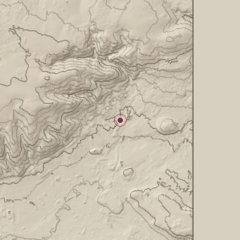
Relief of the ground around the site of Battle of Kulm
Relief within about 10.0 km of the site, contours every 50 m. Copernicus DEM GLO-30, ESA.
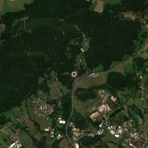
Satellite view of the site of Battle of Kulm today
The same ground from Sentinel-2 on 2025-08-12. Contains modified Copernicus Sentinel data 2025.

The recorded site stands at about 292 m; within 10.0 km the ground runs from 0 to 804 m, 804 m of relief, steep country and today it is 69% tree cover, 22% grassland, 5% built-up.

tree cover: 69%grassland: 22%built-up: 5%tree cover 69%grassland 22%built-up 5%
west to east, 10.0 km0 to 719 mnorth to south, 10.0 km152 to 737 m
Elevation from the Copernicus DEM GLO-30 (ESA, Airbus); land cover from ESA WorldCover 2021 (CC BY 4.0), within about 5 km of the recorded site. Computed, not recorded.

Nearest engagements

Contested ground: this site was fought over 3 times between 1126 and 1813.

In the same war

Elsewhere in 1813

Battle of Kulm is one of 3,694 engagements of the 19th century in the atlas and one of 188 in present-day Czech Republic.

Sources

Identity, coordinates, dates and the war from Wikidata Q48253, released under CC0. Result, belligerents, commanders, strength and casualties from the infobox of the English Wikipedia article Battle of Kulm, revision 1370267506, read 2026-11-14, licensed CC BY-SA 4.0; the article's text is not reproduced here. Present-day country and state from Natural Earth. Dates before 1582 follow the Julian calendar as recorded.