Atlas of Battles

battle, landmark, early modern

Battle of Poltava

Battle of Poltava was a battle fought on 27 June 1709 at Poltava, in what is now Ukraine. It was part of the Great Northern War, which ran from 1700 to 1721. The recorded result: Russian coalition victory.

See it on the globe Read the article

Battle of Poltava
Pierre-Denis Martin, Public domain, via Wikimedia Commons.
Fought27 June 1709
WherePoltava, Ukraine49.631N, 34.553E
OutcomeRussian coalition victory
BelligerentsSwedish Empire; Cossack HetmanateagainstTsardom of Russia; Cossack Hetmanate; Kalmyk Khanate
Casualties and losses9,700 to 12,211and4,635 to 5,953
Part ofGreat Northern War1700 to 1721

Where it sits in the Great Northern War

Siege of Riga, 1700Siege of Riga, 1700Battle of Varja, 1700Battle of Narva, 1700Battle of Petschora, 1701Crossing of the Düna, 1701Battle of Rauge, 1701Battle of Vilnius, 1702Battle of Erastfer, 1702Battle of Dersunisjki, 1702Battle of Klissow, 1702Battle of Hummelshof, 1702Siege of Nöteborg, 1702Battle of Saladen, 1703Battle of Pułtusk, 1703Siege of Thorn, 1703Battle of Systerbäck, 1703Siege of Tartu, 1704Battle of Wesenberg, 1704Siege of Narva, 1704Battle of Orford Ness, 1704Battle of Jakobstadt, 1704Battle of Poznań, 1704Capture of Warsaw, 1704Battle of Lemberg, 1704Battle of Punitz, 1704Campaign of Grodno, 1705Battle of Warsaw, 1705Battle of Gemauerthof, 1705Battle of Praga, 1705Siege of Vyborg, 1706Battle of Fraustadt, 1706Battle of Valkininkai, 1706Siege of Liachavičy, 1706Battle of Grodno, 1706Battle of Kletsk, 1706Battle of Kalisz, 1706Swedish invasion of Russia, 1708Battle of Grodno, 1708Battle of Holowczyn, 1708Battle of Malatitze, 1708Battle of the Neva, 1708Battle of Rajovka, 1708Battle of Koporye, 1708Battle of Lesnaya, 1708Sack of Baturyn, 1708Battle of Koniecpol, 1708Siege of Vepryk, 1708Pursuit of Krasnokutsk, 1709Battle of Poltava, 1709Siege of Riga, 1709Pruth River Campaign, 1710Siege of Vyborg, 1710Battle of Helsingborg, 1710Kexholm Siege, 1710Siege of Reval, 1710Action of 4 October 1710, 1710Siege of Wismar, 1711Sieges of Stralsund, 1711Siege of Stralsund, 1711Battle of Westtief, 1712Siege of Stralsund, 1712Siege of Stade, 1712Battle of Gadebusch, 1712Action of 22 July 1713, 1713Skirmish at Bender, 1713Siege of Tönning, 1713Battle of Helsinki, 1713Siege of Stettin, 1713Battle of Landsbro, 1713Battle of Pälkäne, 1713Siege of Tönning, 1714Battle of Napue, 1714Battle of Gangut, 1714Action of 24 April 1715, 1715Siege of Wismar, 1715Siege of Stralsund, 1715Battle of Rügen, 1715Battle of Stresow, 1715Battle of Dynekilen, 1716Siege of Poznań, 1716Battle of Göteborg, 1717Battle of Strömstad, 1717Siege of Trondheim, 1718Siege of Fredriksten, 1718Rysshärjningarna, 1719Attack on Marstrand, 1719Battle of Ösel Island, 1719Battle of Stäket, 1719Battles at Göta Älv, 1719Battle of Grengam, 1720Battle of Selånger, 172117001721Battle of Poltava, 1709
93 placed engagements of the Great Northern War in time order; taller ticks are more widely documented. Each tick is a link.

Record

Date27 June 1709
PlacePoltava, Ukraine
49.631N, 34.553E
KindBattle, early modern
Strength31,392; 34 artillery pieces; 16,500 in battle; 4 cannons75,000 to 80,000; 102 artillery pieces; 42,660 in battle; 86 cannons
Casualties and losses9,700 to 12,2114,635 to 5,953
Commanders
Battle of PoltavaBattle of PoltavaBattle of the Vorskla RiverBattle of Kurukovo LakeFirst Battle of KharkovKharkiv OperationBattle of Zhovti VodyBattle of the Vorskla RiverBattle of Kurukovo LakeFirst Battle of KharkovKharkiv OperationBattle of Zhovti VodyDniproBelgorodCherkasyKirovohradShebekino100 km49.631N, 34.553E
The recorded site, with the nearest other engagements in the atlas. Present-day coastlines, rivers and borders; towns from Natural Earth.

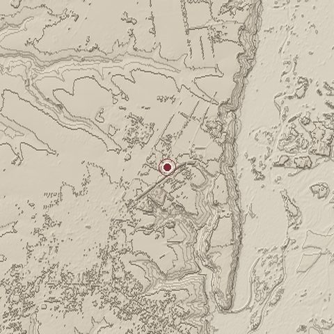
The ground today

Relief of the ground around the site of Battle of Poltava
Relief within about 10.0 km of the site, contours every 10 m. Copernicus DEM GLO-30, ESA.
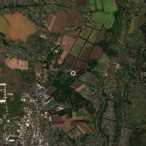
Satellite view of the site of Battle of Poltava today
The same ground from Sentinel-2 on 2023-09-28. Contains modified Copernicus Sentinel data 2023.

The recorded site stands at about 165 m; within 10.0 km the ground runs from 78 to 186 m, 108 m of relief, gently rolling country and today it is 47% tree cover, 27% cropland, 15% grassland.

tree cover: 47%cropland: 27%grassland: 15%built-up: 11%tree cover 47%cropland 27%grassland 15%built-up 11%
west to east, 10.0 km80 to 175 mnorth to south, 10.0 km116 to 167 m
Elevation from the Copernicus DEM GLO-30 (ESA, Airbus); land cover from ESA WorldCover 2021 (CC BY 4.0), within about 5 km of the recorded site. Computed, not recorded.

Nearest engagements

In the same war

Elsewhere in 1709

Combat data (CDB90)

Attacker: SW ARMYDefender: RUSS ARMY
Strength21,50080,000
Casualties9,600 (44.7%)1,300 (1.6%)
Mission accomplishment, 1 to 1048
Outcomedefender won
Duration2 days
Front width1.2 km3.2 km
Attacker advanced-6 km

From the US Army Concepts Analysis Agency Database of Battles (CDB90, battle 49), public domain, in the CC0 tidy edition by Jeffrey B. Arnold. Figures are the database's estimates, compiled in 1990 from published histories, and may differ from the Wikipedia infobox above.

Battle of Poltava is one of 2,126 engagements of the 18th century in the atlas and one of 321 in present-day Ukraine.

Sources

Identity, coordinates, dates and the war from Wikidata Q152486, released under CC0. Result, belligerents, commanders, strength and casualties from the infobox of the English Wikipedia article Battle of Poltava, revision 1382483921, read 2026-11-14, licensed CC BY-SA 4.0; the article's text is not reproduced here. Present-day country and state from Natural Earth. Dates before 1582 follow the Julian calendar as recorded.